
Fin Dome, near the Rae Lakes
In Part 3 of my JMT trip, I have another distant brush with a backcountry airlift, connect with Taylor after his bruising trip up Taboose Pass, avoid getting fried by lightning on a 12,000 ft pass, and reach Mt. Whitney after 211 miles. If you need a refresher or missed them the first time, here are Part 1 and Part 2.
NOTE: I just finished hiking the Tour de Mont Blanc in France, Switzerland and Italy. Check out a GPS map of the route here. Posts about that trip are on the way.
Day 9
Taylor and I planned to meet between noon and 4. Things can always go wrong so I wanted to cover the 8 miles to the meeting point quickly. I flew up Mather Pass and cleared the saddle by 8am. The early start helped me make the Bench Lake junction meeting point by 11am.
Now it was time to wait. And wait. And apparently wait some more. Noon, 1, 2, and 3 came and went. No Taylor.
Despite the waiting though, it wasn’t boring. Early on, three men straining under astoundingly huge loads (one guy had a full 60L pack strapped onto a full 90L pack) went by heading toward Taboose Pass. Their friend had just been airlifted out after a climbing accident on Mt. Erol (“A rock rolled over on him.” Not sure what it meant but it sounded bad.) and they had cut short an extended trip in the backcountry.

On the trail, sometimes you get bored and sometimes you fantasize about real food. When both happen at the same time, you get pictures like this.
At the junction, they decided to lighten their load by leaving what looked to be 20 lbs of food in three huge plastic bags on the trailside. Ostensibly, this was so other hikers would pick it up. That’s great in theory, but a horrible idea in practice. Most of the food they left behind (like a gallon bag of oatmeal) was stuff that no hiker would ever pick up and, of course, there are bears all over the JMT just waiting for a free meal.
As the day went on, hiker after hiker rummaged through the bags (with my strong encouragement) for something to take. Unfortunately though, the good stuff was gone after the first few browsers and, with hikers now few and far between, massive of bags of oatmeal, black bean soup, curry lentil soup, quinoa, and couscous remained.

Unnamed lake near Bench Lake junction
Before I knew it, it was 3:55, just a few short minutes before my window for meeting Taylor would close. I decided I’d been stood up. Throwing my things together, I began the weighty process of deciding how much responsibility I was going to take for all the food on the trail. I didn’t want to carry it but I’d hate to see it end up in the paws of the local ursine population. In mid-thought and with my head buried in my pack and my back to the trail, I heard, “Hey! What’s up!?!” (or something to that effect).
It was Taylor! In between a boisterous greeting and a solid bro hug, we exchanged stories. You already know mine. Taylor’s was far more dramatic.
He’d started his trek up Taboose Pass at 5:50 that morning. Beginning in the high desert (5,400 ft), he made good time over the first part of the climb. Disaster struck with four miles done and four left to the top of the pass (11,360 ft) when the soles of both of his boots blew out. Which was bad. Especially since his boots had previously been to the top of Mt. Kilimanjaro.
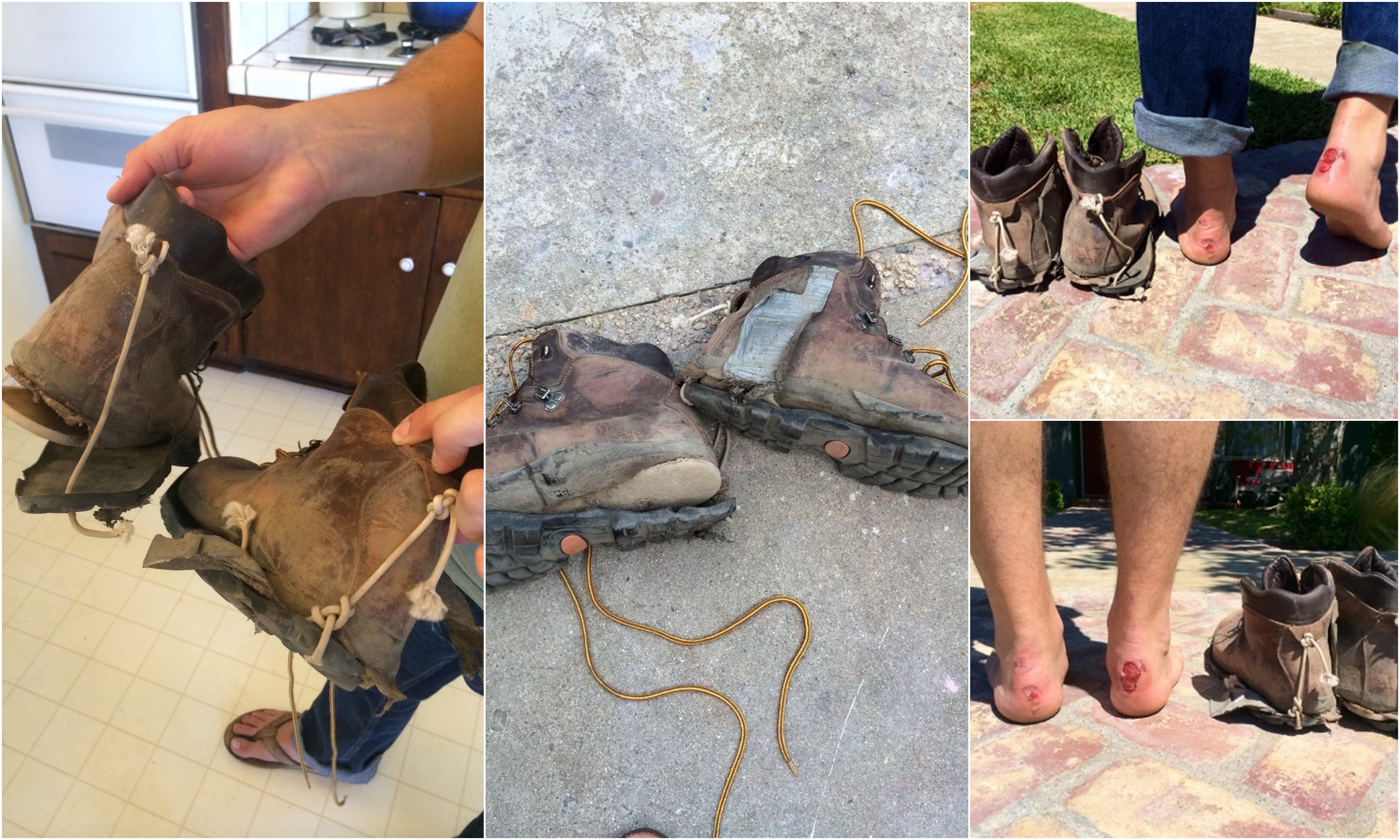
You may recognize this picture from a prior post. It deserves a repeat.
Oddly enough, soon after the blowout Taylor ran into the gentlemen with the astoundingly large packs who had dropped all the food at the junction. They had duct tape and bailing wire stashed in those astoundingly large packs and helped Taylor cobble together the pieces of his boots into something once more resembling a shoe.
It was a valiant effort, but it’s guaranteed that you’re in trouble when duct tape is a major structural component of your boots. And Taylor was. Particularly on Taboose Pass, one of the toughest passes in the entire Sierras. He labored up the rest of the way, hour by hour, and made it to the junction just under the wire.
It became obvious once we got caught up that we weren’t going far that afternoon. We went a quick quarter mile to the nearest lake and set up camp. I spent the night cooking and eating (pad thai, black bean soup, couscous, even some chili-mac), while Taylor mostly kept a close eye on his air mattress. Seemed entirely reasonable on his part.

Luckily Taylor had recovered by the next morning
As for the food that was dumped on the trail earlier in the day, I decided I couldn’t leave it for the bears. I first dragged it to a nearby ranger station that was marked on the map, but it turned to out to be just a research station with no ranger on duty. With no good options, I decided, after briefly contemplating burying the food, to dump it in the nearby river and (have Taylor) pack out the trash. Like Taylor said, it’s hard to imagine trout causing problems because they develop a taste for people food.

A beautiful sunset near the Bench Lake junction for those up late enough to see it.
Day 10
Taylor and I were ready to go early the next morning. Taylor was up because he had a long hike back down Taboose. He had planned to take a day to explore the backcountry, but the previous day’s damage to his shoes proved too much and he decided to head back. Who knew how long that was going to take ? (Because I know you’re interested, it took five hours and the repair job on his shoes mostly held up. His heels, as evidenced by the picture above, were another story.)
I was up early because I had 60 miles to cover and just two and half days left on the schedule. I had to make up miles due to the short mileage the day before. Over the course of the hike, I’d found that I could keep a pace of just better than 2 miles per hour over a full hiking day, which meant I had around 30 hours of hiking in front me. Better get crackin’.

Sunset near Charlotte Lake
The day I had planned was doozy with a lot of altitude change and two major passes. For 3 miles out of Bench Lake junction (10,795 ft), the trail ascended to Pinchot Pass (12,130 ft). Then it dropped over the next 7.4 miles down to 8,492 ft at the South Fork junction. Another 9 miles of ascent and the trail passed the Rae Lakes and came to Glen Pass (11,978 ft). Once over the pass, I was hoping to make it another 3 miles to the Onion Valley junction near Charlotte Lake.
The first 18 miles or so went by without a hitch. Then, to make things interesting, the sky started to darken across the valley as I approached the Rae Lakes. Rounding the lakes and nearing the pass, it was judgment time – should I attempt the pass and risk getting caught up high if the weather shifted or lay low at the lakes that night and face a massive 30+ mile day the next day so I could have a reasonable shot at getting off Whitney at an early hour the next day?

Morning below Forrester Pass
I took a half hour break to take stock and let the weather develop. The dark clouds stayed down the valley, the winds seemed to be off the pass, and my barometer showed that the pressure was tracking steady. All signs seemed good. I decided to give it shot.
Of course, as these things go, the winds shifted as I climbed the pass. The 1,000 foot climb seemed to stretch on forever as huge, grey clouds drifted ominously toward the pass. I was still several hundred feet below the top and the threatening clouds were almost to the pass.
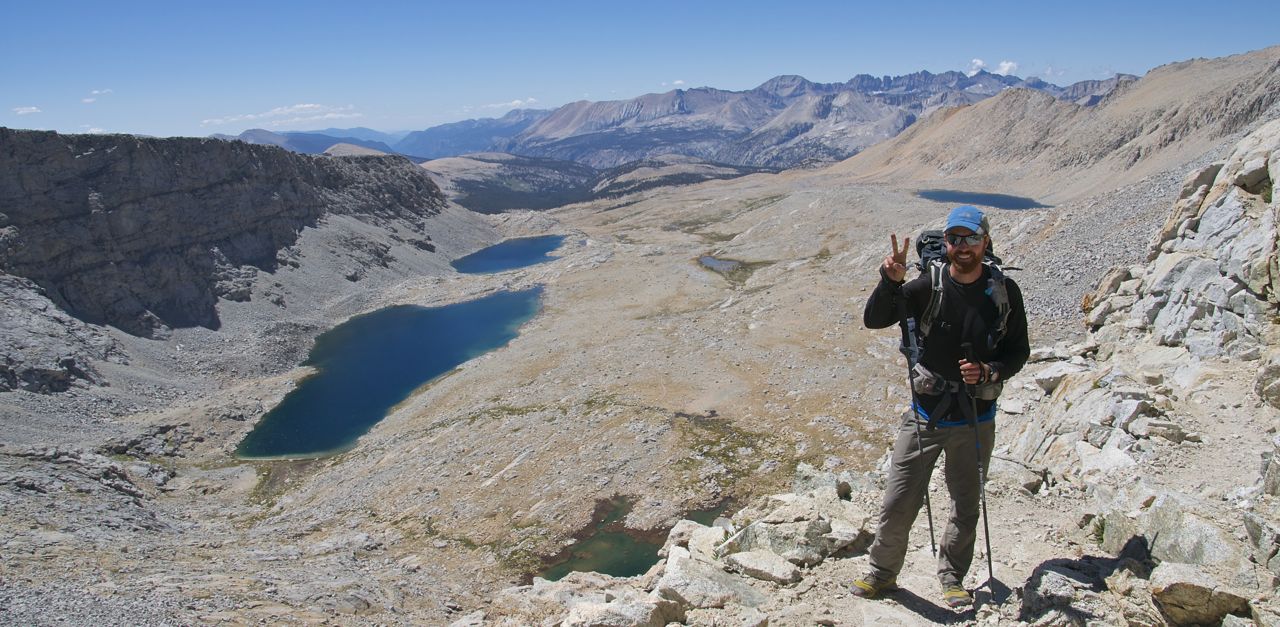
That would be “Hike #2 of 7”. At the top of Forrester Pass.
Rain and cold are the obvious issues when on a pass in weather, but lightning is the real concern. I took no chances. I broke down my trekking poles and stuck them in my pack. Off came the watch. I buried anything metal as deep as I could. Then I hit the accelerator. Now twenty miles into my day, I pounded my way to the top of the pass and began racing down the other side. When I finally took the chance to look back, I saw the clouds drifting lazily away. Harmless.

Mt. Whitney
Day 11
I left my camp near the Onion Valley junction at 7am. I was facing down Forrester Pass (13,100 ft), the highest pass on the JMT and the last one before Mt. Whitney. I wanted to get there as early as possible.
The trail bottomed out at 9,515 ft near Vidette Meadow and then, following Bubbs Creek, rose for 7.4 miles to Forrester. I covered ground quickly. With a brief stop on top of the pass, I continued on past Tyndall Creek, crossed the Kern River, then made my way into Crabtree. One last, 800-foot climb later and I dragged into Guitar Lake just before sunset at the end of a very long day.

In addition to the obviously stellar patriotism on the summit, you should have seen the dance that Yellow Pants was doing. Hilarious!
Guitar Lake was a zoo. I counted at least twenty different tents dotting four different camping areas. The word around the lake was that a good chunk of the people there would be leaving camp at 3:00am to reach the summit by sunrise.
Day 12
I would not be one of them. Didn’t even consider it. I left camp at a much more reasonable 6am and began the 3,000 ft ascent to the highest point in the contiguous U.S. (14,502 ft). I made the pack drop (13,500 ft) by 7:30am and reached the summit by 8:30am.
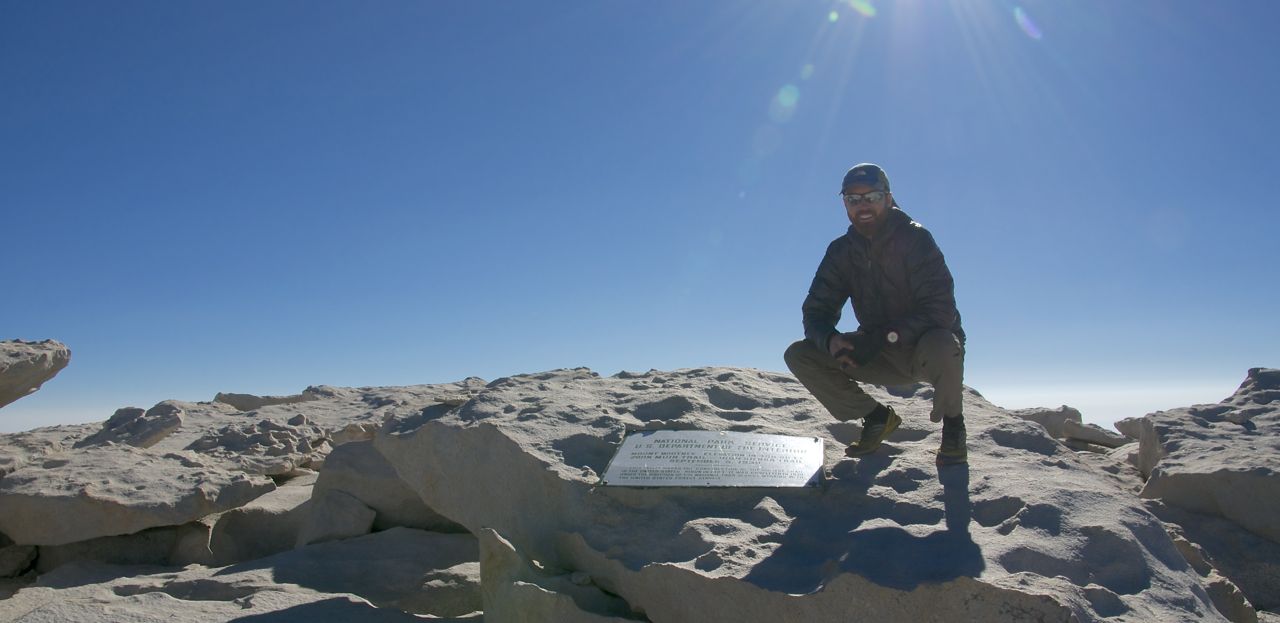
Then it was my turn. (Not pictured – face-numbing 40 mph winds.)
It was my fourth visit to Whitney. This time the usual feeling of accomplishment on reaching the summit had added juice because it also marked the 211th and last official mile of the JMT. After all those miles, now it really was “all downhill from here.”
I coasted the 10 miles down to Whitney Portal and shared my traditional post-Whitney Sierra Nevada Pale Ale with a group from the East Coast who had also just completed the JMT. Then I hit the road for home. I had five days before my flight to Europe for the Tour de Mont Blanc and the clock was ticking.
Hike #2 – North America’s John Muir Trail:


Great accomplishment! Stay young,healthy and adventuresome.
As always i enjoy your photos and the story. Cant wait for trek 3 posts!